
Erin strengthened into a hurricane Friday as the storm continued on a path over the Atlantic Ocean, forecasters said. It is the first hurricane to develop in the Atlantic this year, and it was expected to continue gaining strength, potentially growing into a major hurricane.
Forecasters with the U.S. National Hurricane Center in Miami have been urging people in the Caribbean islands to monitor Erin’s progress, warning of the potential for heavy rainfall and life-threatening surf and rip current conditions.
Hurricane Erin is not currently forecast to impact the United States, but meteorologists continue to watch it closely.
As of 11 a.m. EDT, Erin was some 460 miles east of the northern Leeward Islands and heading west-northwest at 18 mph with maximum sustained winds of 75 mph, making it a Category 1 hurricane.
Maps show Hurricane Erin’s forecast path
Forecasters expected Erin’s path to curve northward, with the hurricane likely passing near the northern Leewards over the weekend. The northern Leewards stretch from the Virgin Islands to Guadeloupe and include St. Martin, St. Barts and other islands.
CBS News
A “spaghetti map” of the forecast models shows the storm pivoting to the north, skirting the islands and remaining well offshore of the U.S. East Coast.
CBS News 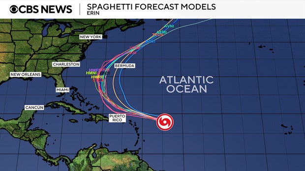
Erin is forecast to continue getting stronger, likely developing into a major hurricane, meaning at least a Category 3 with maximum sustained winds of 111 mph or higher.
First hurricane of the Atlantic season
Erin formed as a tropical storm Monday west of the island nation of Cabo Verde, a few hundred miles off Africa’s western coast. It is the fifth named storm of the 2025 Atlantic hurricane season, which started in June and runs through November.
So far this year, Tropical Storm Chantal is the only one to have made landfall in the U.S., bringing deadly flooding to North Carolina in early July. In June, Barry made landfall as a tropical depression on Mexico’s eastern coast.
Erin’s increased strength comes as the Atlantic hurricane season approaches its peak in September. According to the hurricane center, most of the season’s activity typically happens between mid-August and mid-October. In the eastern Pacific Ocean, hurricane season starts on May 15 with a peak in activity typically seen in late August.
The U.S. National Oceanic and Atmospheric Administration, or NOAA, forecast an above-normal season for the Atlantic this year, expecting between 13 and 18 named storms.
Tropical storms have maximum sustained winds of at least 39 mph. Forecasters with NOAA anticipated between five and nine of the storms this year could become hurricanes, which have sustained winds of at least 74 mph. Hurricanes are rated on a scale based on their wind speeds, ranging from Category 1, the weakest, to Category 5, the most severe rating.
Storms with winds of at least 111 mph are considered major hurricanes and are rated Category 3 and up. NOAA forecasters predicted there could be between two and five major hurricanes in the Atlantic this season.
Source link