The Grand Canyon’s “Swiss Cheese” Rocks Hold a Critical Secret
Researchers are uncovering how underground water systems sustain the Grand Canyon and how they are changing over time.
Every year at Grand Canyon National Park, millions of visitors pause at one of the park’s water spigots. Some are standing along the rim, taking in the view for the first time, and step aside briefly to refill a bottle. Others are far below, deep in the canyon, exhausted from the heat and preparing for a difficult climb out. They refill hydration packs, pour water over themselves, and rely on it to prevent dehydration and heat stroke.
All of that water originates from a single source: Roaring Springs, a cave-fed spring located on the North Rim. It can be seen and heard from the North Kaibab Trail, although there is no direct path to it. This spring supports life throughout the canyon, including people, vegetation, and wildlife. However, it is becoming more vulnerable as temperatures rise and conditions grow drier.
Researchers from NAU’s School of Informatics, Computing, and Cyber Systems are working to better understand Roaring Springs and similar cave-fed systems. With new funding from Grand Canyon National Park, their project will expand mapping efforts to examine how snowfall and underground water systems are connected.
“Understanding where the water sinks is critical for the infrastructure, the animals, the plants, and the rest of the ecosystems that rely on these springs,” said Blase LaSala, a Ph.D. student in ecoinformatics. “They’re like oases.”
The findings were published in the journal Nature Scientific Reports.
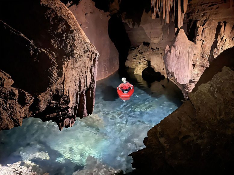
What to know about Grand Canyon’s caves
Because these caves are not open to the public and are often far from established trails, most knowledge about them comes from specialized mapping projects. LaSala’s dissertation work, completed with professor Temuulen “Teki” Sankey, focused on documenting these hidden spaces using advanced remote sensing techniques.
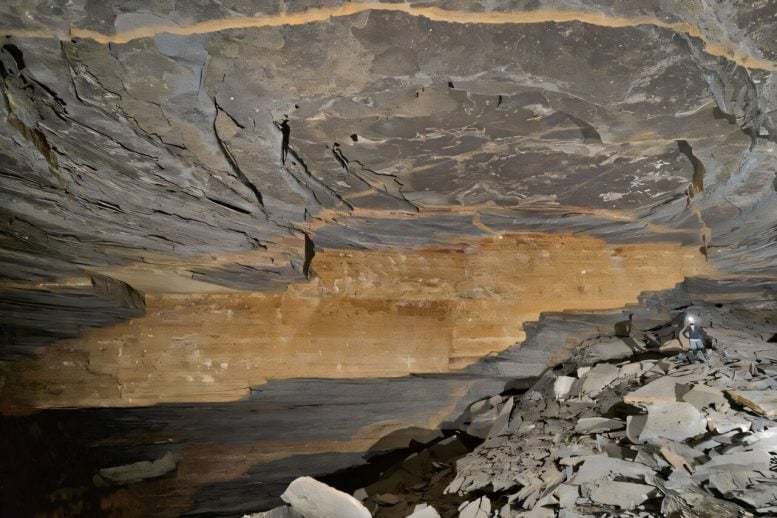
By using a mobile lidar sensor, LaSala produced detailed three-dimensional models of three caves, capturing their walls and ceilings with high precision. Over 45 days, teams of researchers and volunteers mapped more than 10 kilometers of underground passages, including narrow crawls and large chambers.
“I had no idea how large and long these caves are,” Sankey said. “We have been able to produce really high-resolution 3D maps, which, from a remote sensing perspective, is what’s unique and novel about it. Grand Canyon’s caves have never been mapped in 3D like this.”
Reaching these caves required significant effort. Teams carried 55-pound packs over hikes that could take up to two days each way. Once there, they navigated difficult terrain by hiking, rappelling, and even moving through flooded sections. Along the way, they documented structural details such as cracks and formations. These patterns provide clues about how water travels through layers of rock over time.
Where does the water come from?
The short answer is the surface, primarily from snowmelt on the Kaibab Plateau.
The full explanation is more complex. Water must travel through multiple rock layers before reaching the springs. While diagrams often show these layers stacked neatly, the actual pathways are far less direct.
The springs are located in Redwall and Muav limestone, separated from the surface by several other geological layers. Dye tracer experiments conducted by the park have shown that water can move surprisingly fast through this system. Abe Springer, a professor in the School of Earth and Sustainability and a collaborator on the project, has observed dye traveling about 20 kilometers from surface sinkholes to springs in as little as a week.
Even so, the exact routes water takes remain difficult to predict. Movement depends on fractures, faults, and the permeability of the rock, factors that are not yet fully understood.
“The dissertation work was making the geologic connection between what we might see at the surface versus what we might see hundreds or thousands of feet belowground,” Sankey said.
“It’s like looking at a black box,” LaSala added. “You see what comes in and what comes out, but it’s very hard to quantify what’s going on in there. Now that we know what patterns are there, we can really start to relate the data to spring change over time.”
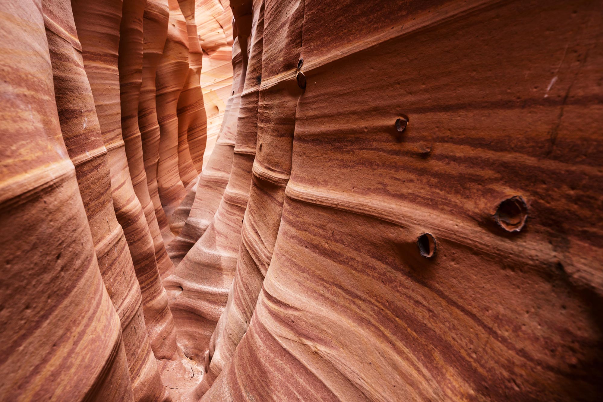
One major concern is contamination. Many of the canyon’s largest springs are karst-fed, meaning the rock contains extensive voids and channels. Sankey compared this structure to “Swiss cheese.” Because water moves quickly through these spaces, there is little opportunity for natural filtration. If polluted runoff or bacteria such as E. coli enters connected sinkholes, it could reach Roaring Springs rapidly. In such cases, park officials may need to shut down water systems until the issue is resolved. Identifying contamination sources is key to preventing future disruptions.
What this new project entails
The next phase of research is set to begin in early 2026. Using airborne lidar and decades of satellite data, LaSala and Sankey will map sinkholes across both sides of the canyon and analyze patterns of snowmelt accumulation over the past 40 years.
Most of the work will take place on the surface, though cave exploration may continue if new systems are discovered. The goal is to better understand geological processes such as sinkhole formation and disappearing streams. By comparing surface patterns with underground structures, researchers hope to clarify how water moves through upper rock layers and improve future dye tracing studies.
Snowmelt trends are especially important, as Arizona has experienced declining snowfall in recent years. The Grand Canyon reflects this shift. The project will generate a large dataset that, combined with lidar and other imaging tools, will help scientists and land managers better understand regional water dynamics.
Although the research directly benefits Grand Canyon National Park, its relevance extends far beyond northern Arizona. More than 1 billion people worldwide depend on karst springs for water, making this work applicable on a global scale. It may also provide valuable insights for Native American tribes located within or near the park.
“It’s exciting to find patterns that verify the hypotheses made over 50 years ago,” LaSala said. “We have all this amazing data now, and we’re trying to combine it with other data to find useful things. There are so many places that could benefit from this type of analysis.”
How does the Dragon Bravo Fire change the research?
Both LaSala and Sankey acknowledged the uncertainty introduced by the Dragon Bravo Fire. Unexpected challenges are common in scientific work, and this is simply another variable to account for.
“It’s a new twist to our study,” Sankey said.
The fire’s effects on the Kaibab Plateau will influence future observations, requiring researchers to factor environmental changes into their analysis. LaSala noted that their team will also support the park in responding to these impacts as needed.
Reference: “Three-dimensional characterization of caves within the Grand Canyon’s deep karst aquifer” by Blase LaSala, Temuulen Tsagaan Sankey, Mark Nebel, Abraham E. Springer and Aria Mildice, 30 August 2025, Scientific Reports.
DOI: 10.1038/s41598-025-17472-6
Grand Canyon National Park supported this research.
Never miss a breakthrough: Join the SciTechDaily newsletter.
Follow us on Google and Google News.
Source link