A Winter Storm Warning remains in effect for most of the Chicago area and Northwest Indiana Monday morning for an unseasonable fall snowstorm that clobbered much of the area with lake-effect snow.
For central Cook County including Chicago, the Winter Storm Warning was downgraded to a Winter Weather Advisory around 5 a.m. But elsewhere in Cook County, the Winter Storm Warning remains in effect.
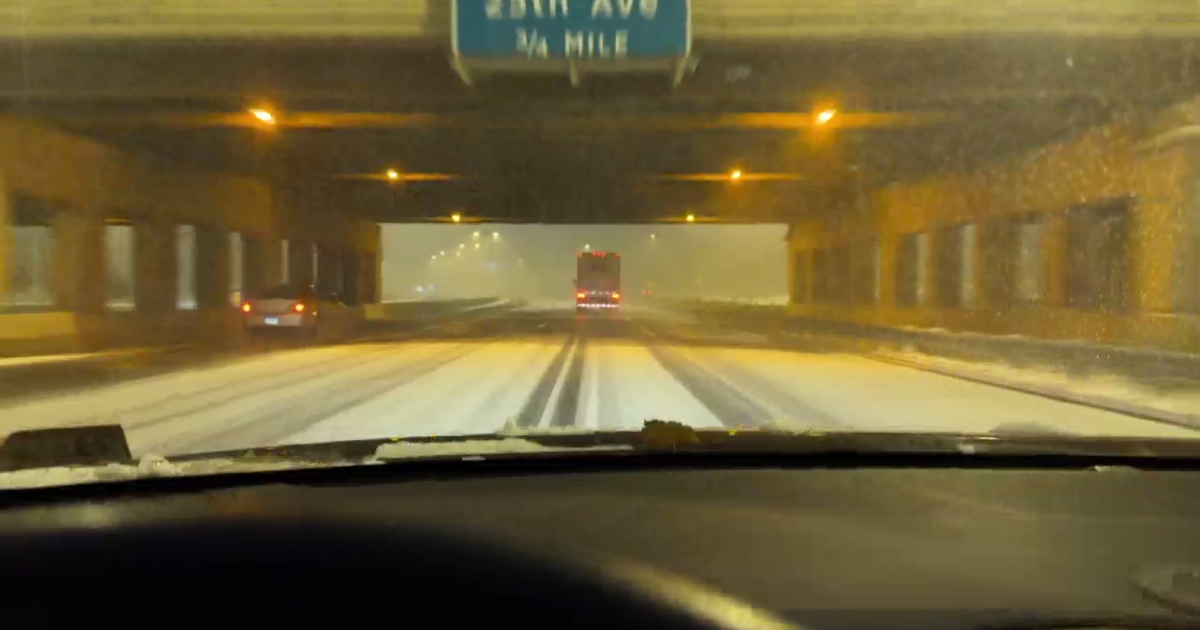
As the morning commute began Monday, the snowstorm was poised to cause extremely hazardous driving conditions.
The snow was falling and intensifying in the Chicago area as early as 8 p.m. Sunday, and picked up through the night with thunderclaps. Accumulations piled up in Cook County and around the lake into Northwest Indiana.
CHECK: School closings | Flight delays | CTA | Metra
A mesolow — a small low-pressure system — moved through the area in the early morning hours, spreading the misery more widely.
The north suburbs, from Kenosha, Wisconsin south through Lake County, were being clobbered with snow that fell at a rate of 1 to 2 inches per hour as of 4:30 a.m.
Downtown Chicago was in a lull as of 4:30 a.m., but this was not expected to last. More lake-effect snow is expected to hit the city before the system peters out.
Even when the snow wasn’t falling, the wind whipped up and blew snow around as motorists made their way up DuSable Lake Shore Drive downtown.
The worst conditions were seen south of Chicago and in Northwest Indiana, with double-digit snow totals and winds gusting up to 50 mph.
The lake-effect snow will become more localized mid-morning through the afternoon as the snow band is expected to pivot around the lake from west to east. With the snow breaking up, totals were expected to fall short of what was expected earlier.
Hazardous to life-threatening travel conditions will be possible throughout the morning as snowfall rates could be from 1 to 3 inches per hour. The visibility could also still drop to near-zero at times, especially underneath a healthy snow band.
The Chicago Department of Streets and Sanitation deployed its snow plow fleet overnight to keep major roads clear. More than 250 salt spreaders were deployed Sunday night into Monday morning.
The snow-fighting fleet focused on addressing snow and ice along DuSable Lake Shore Drive and the city’s arterial routes. Residents can see the snow fleet in action at chicagoshovels.org.
Express buses were not running on DuSable Lake Shore Drive early Monday morning.
Beyond the city, some expressways were treacherous to the point of being impassable as of 4:30 a.m. Poor to no visibility was reported on parts of I-57 south of Chicago and I-65 in Indiana where there is no overhead lighting. Numerous cars with in the ditch, and motorists were advised to stay away.
Meanwhile, O’Hare International Airport was closed to non-scheduled operations and general aviation overnight during the snowstorm. A total of 239 flights have been canceled for when the airport opens for the morning, while 130 flights have been canceled at Midway International Airport.
The Winter Storm Warning will be in effect through noon Monday for the affected parts of Cook County, as well as eastern Will County.
In Kankakee County, the warning begins at midnight Monday morning and also continues through noon Monday. The warning is in effect through 6 p.m. Monday for Lake and Porter counties in Indiana.
For LaPorte County, Indiana, a Winter Storm Warning was already in effect as of midday Sunday and continues until midnight Tuesday morning.
A Winter Storm Warning is also now in effect for Lake County, Illinois, until 6 a.m. Monday. A Winter Weather Advisory will be in effect for DuPage and western Will counties in Illinois, as well as Newton and Jasper counties in Indiana.
Snowfall rates of 3 inches per hour are still a risk.
When it’s all over, snow totaling 4 to 6 inches is expected widely. Localized totals of 8 to 10 inches remain possible, with a spot or two of 12 to 14 inches also still possible — particularly along and just inland from the lake shore.
Source link